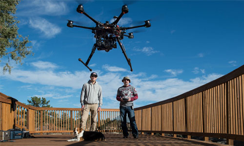
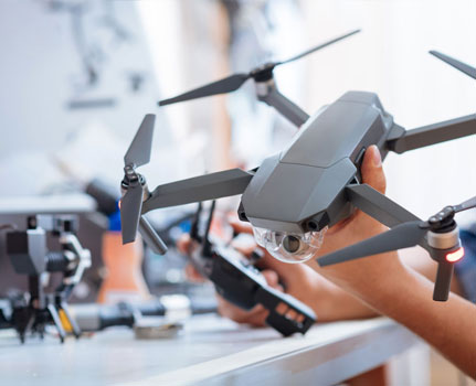
UAV (Unmanned Aerial Vehicle) Services
1) Inspection and Monitoring
Unmanned Aerial Vehicles (UAVs) equipped with cameras have made possible live and/or recorded industrial inspection and monitoring from the air. Examples of live monitoring include the inspection of electric lines, wildfire tracking, and road and bridge monitoring. In other cases, photographs or video taken using a UAV can be analyzed and interpreted post-flight. Agricultural monitoring and renewable energy inspection systems would fall into this category.
a) Agricultural Monitoring
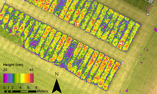
Using a multispectral or hyperspectral sensor on a UAV, many types of agricultural data can be collected from a plot of land. The health of crops can be monitored, and locations of struggling crops can easily be identified, facilitating early intervention in order to increase yield. UAVs can also be used to determine which crops are receiving insufficient amounts of water or to aid in gauging readiness for harvest.
b) Bridge Monitoring
By examining the static state of a bridge, its levels of health and wear can be monitored. The underside and other sections of most bridges cannot be closely inspected without the use of a UAV making it an essential tool for efficient acquisition of high-quality images to aid early detection of bridge damage.
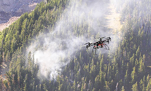
c) Wildfire Tracking
A UAV allows for the detection and tracking of wildfires from the time that they first start. Regular flights during wildfire season allow for more efficient and frequent surveys over a greater surface area.
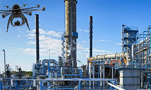
d) Pipeline Management and Monitoring
Oil and gas pipeline leakages and accidents pose a threat to human life and the environment while resulting in severe and wide-reaching material loss. Regular monitoring of pipelines leads to early detection of leaks and damage preventıng threats to public health as well as economic loss and environmental damage. Conducting pipeline inspections with a UAV significantly reduces costs while providing for an increase in frequency of regular inspections.
Similarly, thermal cameras can be used to quickly and effectively determine leaks in hot water lines in industrial facilities.
e) High-Voltage Lines
High-voltage lines are sensitive industrial structures that require regular inspection. Damage caused to these lines can create serious financial loss both for the operator and the consumer as well as environmental damage through fires. Inspections conducted using UAVs in conjunction with infrared and near-infrared multispectral cameras provide fast and extensive results.
f) Renewable Energy
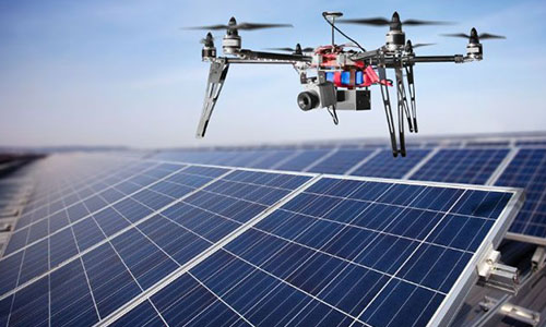
i. Solar Panel Condition Assessment
UAVs are used to determine damage in solar panels using thermal sensors able to detect portions of lower reflectivity. When these portions are replaced, general performance can increase by more than 50%.
ii. Wind Turbine Monitoring
UAVs can provide live assessments of the conditions of wind turbines. Early detection of damage to blades, for example, allows for repairs to be made before more serious problems occur.


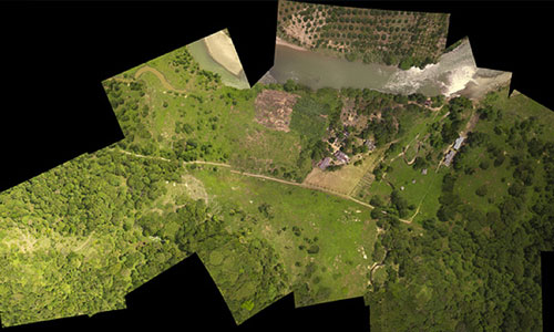
2) Mapping
Mapping or 2D modelling is one of the primary end-products of our UAVs. The many applications include maps of proposed roadways, project sites, and other areas of interest. Orthophoto maps produced with a 1:1 scale can be used for survey purposes. While traditional aerial photography has generally been required to produce these basemaps, UAVs now provide an affordable alternative with centimeter-level accuracy.
3D point clouds or mesh model maps are also available. From these, project site models or elevation models can then be produced.
a) Project Sites
While project site maps are among the most commonly requested maps, obtaining aerial photographs of a site can be costly. UAVs facilitate the efficient and frequent production of basemaps, digital elevation models, and area and volume measurements at a given project site.
b) Biomass Maps
Biomass maps produced using hyperspectral sensors show density of vegetation and other land cover. Biomass maps display differences in vegetation over wide areas or agricultural fields. Vegetation dried out by disease, for example, can also be detected. Other applications include vegetation research and efforts to improve agricultural yield.
c) Road Design
Ground control points used in the acquisition of UAV photography result in a product suitable to be used for detailed roadway design work.

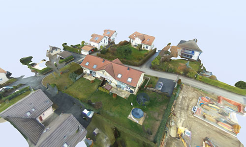
3) 3D Modelling
UAV 3D modelling involves the production of three-dimensional models of an object constructed from point clouds or mesh models. In addition to their use for purely visual purposes or the display of scale, these models can also be used to display elevation, calculate volume, or preserve an historical work for the next generation.
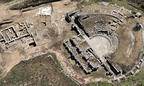
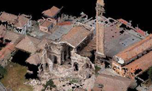
a) Preservation of Historical or Cultural Works
Many historical and cultural works are under threat due to external factors. UAVs provide an effective way of protecting these works through the development of a point cloud from which a solid replica can be produced. These replica models facilitate restoration and repair of any damage to the original work. UAVs efficiently complete the otherwise-complicated task of modelling.
b) Real Estate Property
UAVs can be used in the regular inspection and surveillance of a property. By creating 3D models of a property, a thorough inspection to determine damage for insurance claims can be done very easily. Original models can also be used as a reference for restoration in the event of damage to a structure.
4) Analysis and Consulting
A wide range of analyses can be performed using 2D and 3D models produced from UAV photography. These analyses can be used by our team of experts to provide consulting when necessary.
a) Risk Analysis
As a firm experienced in seismic risk management, UAV-produced maps and models create perspective and an additional medium through which to obtain data for structural and earthquake-related risk analysis.
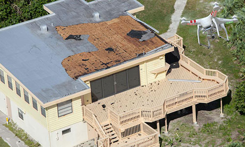
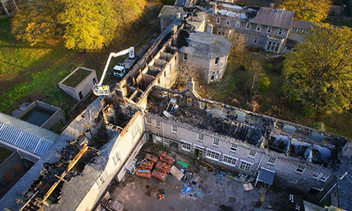
b) Damage Assessment
Damage sustained by a structure can efficiently be surveyed using UAV photography or even quantified with point clouds or mesh models obtained through UAVs.
c) Insurance Claim Assessment
A UAV-produced model of a structure can quickly be generated as a base for analysis to be performed by insurance firms.
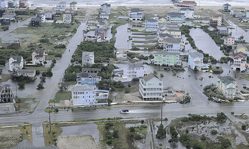
d) Natural Disaster Analysis
UAVs can be used to produce models of certain areas to be used in analysis reports filed after a natural disaster.
i. Flooding
Using certain sensors attached to a UAV, regular monitoring of a river can be performed to determine its tendency to flood. After a flood, analysis reports can be prepared comparing the damage to the stages of the river prior to flooding.
ii. Landslides
Models of a landslide-prone area generated at certain intervals can be used to determine whether or not significant movement has occurred and to detect evidence of a future landslide.
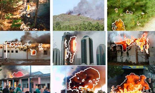
iii. Forest Fires
Through frequent and regular forest monitoring, a UAV can provide an early warning for forest fires preventing loss of life and property as well as environmental damage.

5) Engineering
A UAV efficiently provides high-resolution, photogrammetric surveys. Related engineering applications include volume and surface area calculations, production of elevation contours, support for road design, calculations of excavation and fill, as well as production of Digital Surface Models (DSM), Digital Terrain Models (DTM), and Digital Elevation Models (DEM).
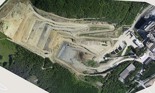
a) Open Mining
A UAV greatly simplifies the process of obtaining calculations of dimensions and volume of an open mine. Further, comparing 3D models of a mine can provide detailed information on deformation at the centimeter-level.
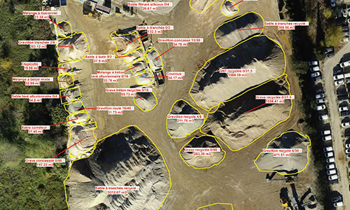
b) Volume Calculation
Using successive UAV-produced point clouds and mesh models, volume changes can be displayed and reported. By comparing models, excavation and fill differences can be displayed and easily quantified.
c) Road Design
Ground control points used in the acquisition of UAV photography result in a product suitable to be used for detailed roadway design work.
d) Digital Surface Models (DSM), Digital Terrain Models (DTM), Digital Elevation Models (DEM)
A UAV provides for the efficient generation of accurate DSM, DTM, DEMs, and associated contours.